


-
 +1 +1
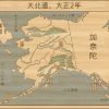
+1 +1Daihodu
A brilliant map by snackserv on deviantart, this piece shows off Alaska, as imagined how it would look if owned and colonized by Japan rather than the United States or Russia. This version is in Japanese, but click the link to see it annotated for convenience.
-
 +2 +1
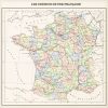
+2 +1France: Regions, Provinces, and Railways
Another map by the excellent 1Blomma, this one of a France who, after a victory in the Franco-Prussian War of 1870, annexes a great deal of land and becomes an industrial and economic powerhouse as a result. Perfectly fitting for Bastille Day, I would think. Vive la France!
-
 +1 +1
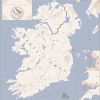
+1 +1Kingdom of Smerte i Raeva
A particularly beautiful map by Soaring Aven, this piece shows a world in which Norse Viking raiders manage to subdue the Emerald Isle and consolidate it into a single kingdom with which to raid Great Britain with.
-
 +2 +1
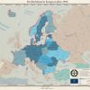
+2 +1Reichsbund 1956
A map by Arminius1871, this map depicts a world in which the German Empire won World War I and thus created a system of alliances that dominated Europe after the war, and for many decades after that. However, by 1956 the Soviet Union, Great Britain, Italy, Spain, and other states have allied against Germany, and it is only a matter of time until German will be at war once more to control Europe.
-
 +1 +1
+1 +1The World Cromwell Made
Another map I made, this one showing a world in which Cromwell lives for 10 years longer, preserving the Commonwealth in Great Britain. This leads King Charles and his supporters to settle in the Catholic colony of Maryland, where they, over the years, consolidate power with their French and Russian allies to create a North America empire spanning from sea to shining sea. The world is at peace, but friction between Commonwealth New England and Maryland could explode at any time.
-
 +2 +1
+2 +1USSR 1958: Union Republics
This is a map by Kuusinen on deviantart, as part of his ongoing series depicting a USSR that decisively won World War II and created a world communist empire.
-
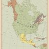
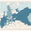
 +9 +1
+9 +1The Commonwealth of America
A map by the excellent edthomasten on deviantart that depicts a world in which the Galloway Plan was accepted by the first Continental Congress in 1774, and implemented after a failed rebellion in Massachusetts in 1775. This plan made the British colonies in North America into a Commonwealth under the British King, which eventually spread across the continent as one mighty nation.
-
 +10 +1
The Pale Continent
Map by rvbomally on deviantart. This map depicts a world in which, unlike in our own in which Europe was blessed with luck, the Mongols managed to conquer the majority of Europe and turn it into their own domain, and Europe never full recovered their own identity from it, resulting in the map in the language you see here.
-
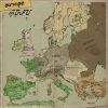
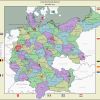
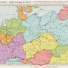 +3 +1
+3 +1What Is This Germany You Speak Of?
A map by the fantastic 1Blomma that shows the outcome of a proposed plan to split Germany up completely forllowing World War II in order to preserve peace.
-
 +8 +1
+8 +1The Icelandic Commonwealth
A map by the very talented Kuusinen on deviantart, this one depicts an alternate world in which his native homeland of Iceland manages to get over 1 million people and builds an Arctic empire for itself.
-
 +8 +1
+8 +1A Song of Steam and Gears
Another one of the maps I've made, this one an alternate history of A Song of Ice and Fire in which the Valyrians, rather than discovering dragons, discover the power of industrialization. This is a map set around 300AC, around the 4th and 5th books in the A Song of Ice and Fire series, with history very much changed.
-
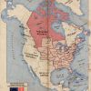
 +2 +1
+2 +1The Nation of Brotherly Love
Another one of my own maps (yay for self-promotion), one I did nearly a year ago. This is a map of North America in a world where a slight difference at the Constitutional Convention results in the USA having its capital in Philadelphia and expand to different horizons all across North America. the map is set in 1954, a couple decades after a massive war shook the world and in a time when the USA is on top of the whole world with allies both north and south of themselves.
-
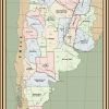 +1 +1
+1 +1Provincias Unidas del Rio de la Plata
A map by nanwe01 on deviantart, this one shows the United Provinces of the Rio de la Plata in 1910, 100 years after their successful unification in 1810 and their subsequent rise to a South American Great Power.
-
 +1 +1
+1 +1Greater Prussia
A map by the excellent 1Blomma on deviantart depicting a successful German Spring Offensive in 1918 that results in a German victory in World War I and Prussia annexing all of Belgium and most of Russian Poland.
-
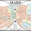 +1 +1
+1 +1The Second Death of the Red World
Created by Ammonoidea on deviantart, this is a different sort of map from most on here. Not only depicting another world, but an alternate future (hopefully) rather than the past. Here, humans colonized Mars and began the process of terraforming...only to be stopped when a mega-virus ripped through Earth. Though the virus was stopped before it reached Mars, the people there lack the resources to continue terraforming the planet, leaving the Red World to die for a second time.
-
 +2 +1
+2 +1The German Empire in 2014
A map by Pischinovski on deviantart, this depicts a world in which Wilhelm II of Germany dies early, in 1904, and thus the German Empire, with better leadership, is able to survive into 2014 free of Nazis and the Cold War, though with significant changes along the way.
-
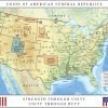 +9 +1
+9 +1Union of American Federal Republics
A map by rvbomally on deviantart showing a much darker alternate United States. In this world, John Wilkes Booth and allies succeeded in assassinating not just Abraham Lincoln, but Vice President Johnson and Secretary of State Seward. In the much more extreme world that follows, America eventually morphs into a fascist dictatorship divided along ethnic lines into new "federal republics".
-
 +2 +1
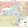
+2 +1Map of New York
An alternate map of an independent New York by GarudaTeam on deviantart. This one depicts a world in which New York rebelled from the United States in 1894, won its independence in 1896, and had Teddy Roosevelt as its first President, creating a regional economic power.
-
 +3 +1
+3 +1United Kingdom of Scandinavia
A map of a United Kingdom of Scandinavia by Kuusinen on deviantart. In the artist's own words, the map depicts a Scandinavia that remained united under the Kalmar Union to the present day, rather than dissolving in the 16th century.
-
 +8 +1
+8 +1The Grand War
A map I made myself, depicting a world where a Muslim China rose after a fateful rebellion, which in our world killed nearly 100,000 rich Muslims in China in the 800s, never happened. This map, written in a modified version of Anglo-Saxon English due to no Norman invasion, depicts the world on the brink of a massive world war between all the major nations of the world. Continue to the deviantart page for a more detailed description and a link to the map in English.
Submit a link
Start a discussion