


-
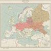
 +2 +1
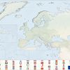
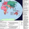
+2 +1Europa Invicta
Created by Pischinovski, this is how he imagines the European Union (and the area around it) by the year 2058. Certainly an optimistic view, but one beautifully realized.
-
 +13 +2
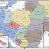
"Velvet" What?!
A very imaginative map by SoaringAven on tumblr, imagining a world where the Velvet Revolution is not nearly so peaceful, leading to a communist Czech SSR in the middle of de-communized Europe. As always, check the external link for more info.
-
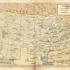
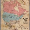
 +2 +1
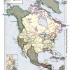
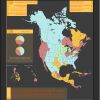
+2 +1A Very Odd USA
In this map by Ammonoidea, some more plausible ideas of history are thrown out in order to get a very interesting and detailed map of North America in which the world took a sharp turn away from ours in the 1810s and never looked back.
-
 +20 +1
Freedom and Unity
A map by yours truly showing an alternate world in which Ghana was able to overcome its initial difficulties and become a West African powerhouse and eventual founder of the African Economic Community, similar to our own world's European Union.
-
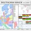
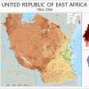 +17 +1
Deutsch-Ostafrika
A map by yours truly, this one depicts a world in which Germany managed to win World War I and retain its colonies, specifically East Africa (the nations of Tanzania, Burundi, and Rwanda in our world). Following the war, millions of Germans migrate to the colony for economic benefits and help make the United Republic of East Africa the powerful and influential nation it is in the "present" of 2004.
-
 +17 +1
Republic of Ezo
Another excellent contribution for deviantart cartographer zalezsky, this map shows an independent Republic of Ezo (Ezo being another word for the Japanese-held island of Hokkaido) after breaking free of Japan in 1869. By the early 20th century, the small island nation has become a formidable minor power in its own right, industrializing and projecting power in the North Pacific.
-
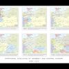 +19 +1
Two Germanies 1864-1925
By the talented cartographer Kuusinen, this map series shows an alternate development of Germany starting in 1864 as, unlike in our world, Prussia and Austria split Germany between them into their own empires, though doing so did little more than result in Germany's splitting again by 1925.
-
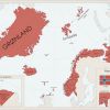 +1 +1
+1 +1The Land of Cold, Oil, and Codfish
A map by Fenn-O-Manic on deviantart, this shows the rather ambitious claims of land by Norway's Quisling government during WWII, and if the Germans had one then the Norwegians would have hoped to receive all this territory in return.
-
 +1 +1
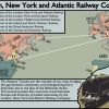
+1 +1Rail-Punk: The LNYA
Something a little different than what I normally post, this may by martin23230 shows a world in which rail, rather than airplane, travel remains dominant to the point of creating underwater tunnels across the Atlantic Ocean to connect Britain with North America. A little far-fetched, maybe, but definitely an exciting and interesting idea.
-
 +2 +1
+2 +1U.S. Presidential Election 2012 (Draka Series)
An excellent map by the brilliant cartographer Sapiento, this unusual sort of map shows elections in the United States in an alternate version of the world of S.M. Stirling's "Draka" series, in which the United States, rather than the hyper-racist expansionistic Draka, were victorious in the end, but at a great cost; regular elections have only just begun to be held again in 2012, years after the last war with the Draka.
-
 +1 +1
+1 +1The Grasshopper Lies Heavy
This map, by QuantumBranching on deviantart (B_Munro on alternatehistory.com), is a good example of why that, for some map makers, you don't need fancy graphics to tell a good story. The map is here, but the full description is available through the link, which I'd fully recommend. The map itself is an imagining of "The Grasshopper Lies Heavy", the book-within-a-book of Philip K. Dick's "The Man in the High Castle", where, here, the British and United States are their own Cold War.
-
 +2 +1
+2 +1Look to the West
A fantastic and detailed map by ImperatordeElysium on deviantart depicting North America as seen in the alternate history timeline "Look to the West" by Thande on alternatehistory.com. Definitely a timeline worth checking out!
-
 +1 +1
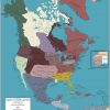
+1 +1Dixie
Another post that shows multiple maps in the same universe, this time for rvbomally's "Dixie" scenario. Basically, the CSA manages to win the Civil War...but quickly collapses under its own weight a few years later, resulting in a rump CSA, the USA annexing the Upper South, and a few of the former CSA states going on their own.
-
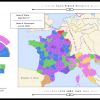 +2 +1
+2 +1The First French Empire
Another map by the very skilled Pischinovski, this one instead of the usual political map instead showing the political makeup of a surviving and powerful French Empire, as well as showing off a few of the surrounding nations.
-
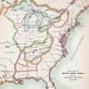
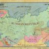 +14 +1
The Russian Republic
This handsome map is the product of LordRoem on deviantart and shows a world in which the Russian Republic (proclaimed in 1917 but fell 8 months later to the Soviets) survives, despite losing a good bit of territory.
-
 +1 +1
+1 +1Germania
Another map series featuring Germany, this time by artist 1Blomma. This one features a Germany that, against all odds, was successful in World War II and won the war. Do note, however, that neither I nor the author support National Socialism or any of its causes and absolutely abhor the Nazi regime of the Second World War; these maps are purely for conceptualization of the idea, not a wish for such a thing to have happened.
-
 +1 +1
+1 +1Austrian-United Greater Germany
This one is a big treat, as HouseofHesse on deviantart didn't just make a single map, but a whole series of graphics detailing a universe that he created out of his map idea of a Germany founded and led by Austria rather than Prussia.
-
 +3 +3
+3 +3Fredonian Republics
A map dafreak47 featuring a scenario in which the Continental Army lost the Battle of Saratoga, resulting in an eventual loss of the 13 Colonies back to the British in the American Revolutionary War. However, not to go down without a fight, patriots settle the western territories beyond the Appalachian Mountains, creating the American Republic and Appalachian Free State to stand against the British colonies of the East Coast.
-
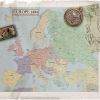 +1 +1
+1 +1Europe 1884
A map by enannglenn showing Europe in the aftermath of a colossal war between Prussia and Austria over Schleswig-Holstein that engulfed all of Europe, resulting in the rise of the German Empire and other regimes across Europe. One of my personal favorite maps, and, essentially, the map which got me into alternate history cartography.
-
 +2 +1
+2 +1British Skylanes
An alternate history map by Alt-Reality on deviantart showing North America after an alternate Civil War that results in a steampunk world in which Britain is king.
Submit a link
Start a discussion