


-
 +7 +1
+7 +1Don't Everyone Move At Once, But You Can Drink On The Street In These Cities
In most places, you could be standing on your own property swilling a tasty hot toddy or sipping an ice-cold beer, but should you step out onto a public street, you’re breaking the law. That’s not the case, everywhere, however. At the risk of inspiring a mass migration to these magic places (not that we condone overdoing it ever and don’t drink and drive), there’s a handy list of towns where it’s actually legal to drink in public.
-
 +22 +6
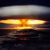
NUKEMAP
A Google Maps mash-up that calculates the effects of the detonation of a nuclear bomb.
-
 +12 +3
This Map Shows Where To Expect A White Christmas
Songwriter Irving Berlin dreamed of a “White Christmas.” The National Oceanic and Atmospheric Administration (NOAA) went even further and calculated the historical probability of a white Christmas for the entire contiguous United States.
-
 +20 +3
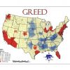
Maps of Seven Deadly Sins in America
Geographers from Kansas State University have created a map of the spatial distribution of the Seven Deadly Sins across the United States. How? By mapping demographic data related to each of the Sins.
-
 +15 +4
U.S. States Renamed For Countries With Similar GDPs
The creator of this map has had the interesting idea to break down that gigantic US GDP into the GDPs of individual states, and compare those to other countries’ GDP.
-
 +18 +5
This adopted man found his parent 25 years later, online.
Love this piece from Google. He found his parents, tracing his childhood memory against Google Map satellite images. Kudos to him and kudos to Google.
-
 +17 +7
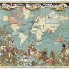
Map of the British Empire in 1886
This map is just before the Scramble for Africa where within 15 years, most of the continent had also been divided up between European powers, with the British Empire getting a very large share.
-
 +16 +3
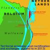
Sex, Drugs and Border Changes
A combination of sex and drugs (and possibly rock 'n roll) is forcing two governments to change the border that divides them. The Presqu'ile de l'Islal, a small Belgian peninsula stranded on the Dutch bank of the river Meuse, is to change hands to eliminate a zone that is, to all practical effects, quite literally beyond the law.
-
 +16 +4
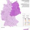
A Ghost of May Days Past: East Germany Rises Again!
Long time, no see: the DDR resurfaces - on a 2013 electoral map.
-
 +12 +4
The "Known World" from 2348 B.C. to A.D. 1828, in the Form of a Single GIF
Englishman Edward Quin’s 1830 atlas, Historical Atlas in a Series of Maps of the World as Known at Different Periods, with an Historical Narrative, featured 21 plates that visually depicted what Quin called “the world as known at different periods.” Dramatic clouds cover the “unknown,” rolling back slowly as time moves on.
-
 +22 +4
40 maps that will help you make sense of the world
If you’re a visual learner like myself, then you know maps, charts and info graphics can really help bring data and information to life. Maps can make a point resonate with readers and this collection aims to do just that. Hopefully some of these maps will surprise you and you’ll learn something new. A few are important to know, some interpret and display data in a beautiful or creative way, and a few may even make you chuckle or shake your head.
-
 +20 +4
Painted Ships on Painted Oceans: an Accidental Map of the Doldrums
Take millions of data points, each one a geolocated entry plucked from a digitised collection of 18th- and 19th-century ships’ logs, pin them all on a blank canvas, and you get this extraordinary world map.
-
 +15 +4
An Interactive Scale of the Universe
What does the universe look like on small scales? On large scales? Check out the interactive map. Grand Universe image .by ANTIFAN-REAL
-
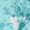 +20 +7
Mapping Poverty in America
Data from the Census Bureau show where the poor live.
-
 +21 +7
40 more maps that explain the world
Maps can be a remarkably powerful tool for understanding the world and how it works, but they show only what you ask them to. You might consider this, then, a collection of maps meant to inspire your inner map nerd. I've searched far and wide for maps that can reveal and surprise and inform in ways that the daily headlines might not, with a careful eye for sourcing and detail. I've included a link for more information on just about every one. Enjoy.
-
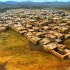 +14 +3
Çatalhöyük ‘Map’ Mural May Depict Volcanic Eruption 8,900 Years Ago
A new study suggests a mural excavated at the Neolithic site of Çatalhöyük in Turkey may be based on the eruption of nearby Mount Hasan around 6900 BC.
-
 +19 +7
China's Chicken Syndrome, and the Man in the Iron Curtain
Stare long enough at these twin images, and you will never see a map of China again without thinking of an agitated chicken flapping its wings as it runs eastward to chase a - what is that?
-
 +13 +4
This World Map Shows The Enormity Of America's Prison Problem
About 2.4 million people live behind bars in America — the highest number in the world. That's a little more than 0.7% of the population and more than 700 for every 100,000 people. This world map illustrates how disconcerting that is. The size of each country corresponds to the size of its total prison population (as of 2010), and a darker color indicates a higher incarceration rate.
-
 +15 +5
How Vaccine Fears Fueled The Resurgence Of Preventable Diseases
An interactive map shows how measles and whooping cough have made a comeback in the U.S. and Europe.
-
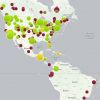
 +16 +5
Best Countries For Backpacking Map
1) View the world based on the best countries for budget backpackers. 2) Hover over countries to view stats in safety, cheapness, friendliness, & our World Travel Expert's Ranking (WTE Rank). 3...
Submit a link
Start a discussion