


-
 +12 +2
Geocoding: Comparing New & Old Methods
Do new tools available for geocoding addresses improve enough on what we already have?
-
 +3 +2
+3 +2Citi Bike Analysis and Automated Workflows with QGIS
Citi Bike, the bike share system in New York City, provides some interesting data that can be analyzed in many different ways using QGIS.
-
 +3 +2
+3 +2Researchers use Arctic sea floor mapping to piece together earth’s history
Researchers from MacEwan University will use Arctic sea floor mapping research to understand the past, and present a key to the future. “Its about the closest thing we can get to a time machine,” says Mark Furze, of the research that he and Anna Piénkowski, faculty members in the department of Physical Sciences, will be doing over the next three years.
-
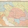 +3 +2
+3 +2Austria-Hungary, early 1900s
While the artist usually does alternate history maps, this is a map done by him that shows our own world's Austria-Hungary and surrounding countries in the early 1900s, before the Balkan Wars.
-
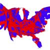
 +13 +3
Mapping the U.S. by Property Value Instead of Land Area
Troubling inequities are revealed when you look at the country by total property values.
-
 +9 +3
+9 +3Bad Maps Are Everywhere These Days. Here's How to Avoid Being Fooled
Tips from a geographer who's seen it all.
-
 +17 +2
Journey To The Center Of The United States
It’s a question that seems so simple as to be stupid, and yet it’s been the focus of debate among American government scientific agencies for over a century: Where, exactly, is the center of the United States of America? In 1901, the U.S. Coast & Geodetic Survey decided, with an oddly cavalier attitude, all things considered, that a place called Meades Ranch, in Kansas, would serve as a survey marker roughly representing the center of the country.
-
 +12 +2
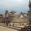
Nepal: Facts About Geology & Culture
Nepal is a narrow, landlocked country directly north of India and below China. Located where two tectonic plates meet, it the area is prone to earthquakes.
-
 +14 +2
30 fake maps that explain the world
These maps may be no good for directions. But they still tell us a lot about the world.
-
 +4 +2
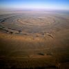
+4 +2The Richat Structure
The Richat Structure of Guelb er Richat in Mauritania is a landmark astronauts see as they pass over the Sahara. Originally thought to be a meteorite impact, it is now known to be a volcanic bulge that never erupted and was leveled by erosion.
-
 +36 +2
The Mystery of Extraordinarily Accurate Medieval Maps
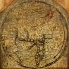
One of the most remarkable and mysterious technical advances in the history of the world is written on the hide of a 13th-century calf. Inked into the vellum is a chart of the Mediterranean so accurate that ships today could navigate with it. Most earlier maps that included the region were not intended for navigation and were so imprecise that they are virtually unrecognizable to the modern eye.
-
 +21 +2
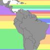
If You Went Straight Across the Ocean, Here's Which Country You'd Hit
Maps can be a tricky thing — just ask Christopher Columbus where he took the wrong turn to "discover" America. Luckily for us, Mental Floss writer Jason English has put together this cool map that highlights which countries you will hit if you start out from the Americas and travel across the ocean in a straight line.
-
 +15 +2
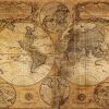
Maps That Shaped the World
Bursting with information and often incredibly beautiful - maps do more than just showing you where you are, or where you might be going.
-
 +24 +2
100 Years of National Geographic Maps
National Geographic maps have charted every mountain, river, lake, road, reef, fjord, island, inlet, glacier, ocean, planet, galaxy, and solar system. The coordinates of the office of The Geographer of the National Geographic Society are 38° 54' 18" N, 77° 2' 12" W. You might say that Juan José Valdés, who currently holds that title, knows exactly where he stands. But the scope of National Geographic's cartographic department, which celebrates its hundredth anniversary this year...
-
 +4 +2
+4 +2What the world values, in one chart
The Inglehart-Welzel map offers a global look at our values and beliefs.
-
 +9 +2
+9 +2New satellite maps out Napa Valley earthquake
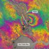
Scientists have used a new Earth-observation satellite called Sentinel-1A to map the ground movements caused by the earthquake that shook up California's wine-producing Napa Valley on 24 August 2014.
-
 +14 +2
Va. man plants flag, claims African country, calling it ‘Kingdom of North Sudan’
Jeremiah Heaton creates “Kingdom of Northern Sudan” by staking claim to 800-square mile swath of desert.
-
 +14 +2
Why do so many nations want a piece of Antarctica?
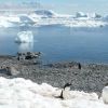
Seven countries have laid claim to parts of Antarctica and many more have a presence there - why do they all want a piece of this frozen wasteland? I pick a path between rock pools and settle my bottom on a boulder. A spectacular, silent view unfolds across a mountain-fringed bay. Then there is a flash in the shallows by my feet - an arrow of white and black.
-
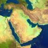 +36 +2
40 Maps That Explain The Middle East
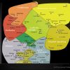
Maps can be a powerful tool for understanding the world, particularly the Middle East, a place in many ways shaped by changing political borders and demographics. Here are 40 maps crucial for understanding the Middle East — its history, its present, and some of the most important stories in the region today.
-
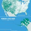 +17 +2
Nobody lives here: The nearly 5 million Census Blocks with zero population
A Block is the smallest area unit used by the U.S. Census Bureau for tabulating statistics. As of the 2010 census, the United States consists of 11,078,300 Census Blocks. Of them, 4,871,270 blocks totaling 4.61 million square kilometers were reported to have no population living inside them. Despite having a population of more than 310 million people, 47 percent of the USA remains unoccupied.
Submit a link
Start a discussion