


11 years ago
1
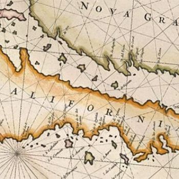
18 Maps From When the World Thought California Was an Island
Glen McLaughlin wandered into a London map shop in 1971 and discovered something strange. On a map from 1663 he noticed something he’d never seen before: California was floating like a big green carrot, untethered to the west coast of North America. He bought the map and hung it in his entryway, where it quickly became a conversation piece. It soon grew into an obsession. McLaughlin began to collect other maps showing California as an island.
Continue Reading http://www.wired.com

Join the Discussion
Plot twist... it was an island until the great earthquake if 1723.