


-
 +20 +4
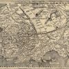
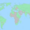
This 509-year-old map contains the first known use of the word 'America' — but not where you may think
In April 1507, German cartographer Martin Waldseemüller published his Universalis cosmographia secundum Ptholomaei traditionem et Americi Vespucii aliorumque lustrationes, or The Universal Cosmography according to the Tradition of Ptolemy and the Discoveries of Amerigo Vespucci and others. It was the first known map to feature parts of the New World labeled “America,” derived from the Latin version of Vespucci’s first name.
-
 +9 +3
+9 +3Rail Crossing Warnings Are Sought for Mapping Apps
The National Transportation Safety Board asked tech companies to add the locations of grade crossings into digital maps and to provide alerts for drivers. By Daisuke Wakabayashi.
-
 +14 +1
This is the best research we've seen on how many Americans are really struggling financially, and it is heartbreaking
A staggering number of Americans aren't making a living wage.
-
 +17 +5
Tune into Homegrown Radio Stations from Around the World
The new website Radio Garden allows you to click through radio stations as they stream in real time, from hundreds of cities in the world.
-
 +33 +10
New map reveals shattering effect of roads on nature
Rampant road building has split the Earth’s land into 600,000 fragments, most of which are too tiny to support significant wildlife, study shows
-
 +27 +6
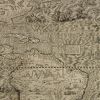
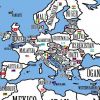
In 1562 Map-Makers Thought America Was Full of Mermaids, Giants, and Dragons
In the 15th and 16th centuries, the mysterious lands of the western hemisphere were a misty haze of tales and stories. After Christopher Columbus set foot in the New World, curious Europeans ate up fantastic sagas about sea monsters, exotic wildlife, and foreign civilizations. Teasing out fact from folklore created an ever-growing obstacle for depicting what the Americas truly looked like.
-
 +5 +1
+5 +1CIA Releases Declassified Maps from 75 Years of Intelligence Cartography
To mark the 75th anniversary of its Cartography Center, the Central Intelligence Agency (CIA) shared decades of declassified maps.
-
 +31 +8
Here Are Some Joyously Random Facts About Half the Countries in the World
If you’re a map nerd or a history buff or someone who likes to travel or just a person who enjoys learning new things, the latest video from Wendover Productions is an absolute delight to watch. It’s a quick tour of all the countries in the world (this is the first part, so exactly half the countries show up) filled with totally random but fun facts about each country.
-
 +2 +2
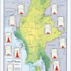
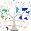
+2 +2The tree of anthropological types by V. V. Bunak
There are many classifications of human phenotypes, but each of them makes us recall the history and the present state of mankind.
-
 +16 +7
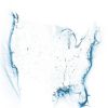
Six maps that show the anatomy of America’s vast infrastructure
A look at the United States’s bridges, electrical grid, pipelines, railroads, airports and waterways. By Tim Meko.
-
 +20 +10
The Woman Who Sees Time as a Hula Hoop
A small group of people see calendars not as grids, but as as rings, check marks, and other objects that seem almost vividly real. By Ed Yong.
-
 +7 +2
+7 +2Now Santa's House In The North Pole Is Listed On Zillow
Imagine binge-watching holiday movies and nomming on cookies in Santa Claus' house!!!
-
 +14 +3
Falling Fruit
A massive, collaborative map of the urban harvest uniting the efforts of foragers, freegans, and foresters around the world. Explore and share information about the sources of free food in your neighborhood.
-
 +18 +7
The Chimney Map
-
 +13 +4
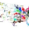
Four Million Commutes Reveal New U.S. 'Megaregions'
As economic centers grow in size and importance, determining their boundaries has become more crucial. Where do you fall on the map?
-
 +15 +3
Globe Making (1955)
-
 +26 +4
American Democracy Betrayed
Ratf**ked: The True Story Behind the Secret Plan to Steal America’s Democracy is a sobering and convincing account of how the Republicans figured out the way to gain power in the state legislatures and, as a consequence, in the federal government through an unprecedented national effort of partisan redistricting. By Elizabeth Drew.
-
 +11 +4
Map of the world's countries rearranged by population.
What if the world were rearranged so that the inhabitants of the country with the largest population would move to the country with the largest area? And the second-largest population would migrate to the second-largest country, and so on? The result would be this disconcerting, disorienting map.
-
 +30 +4
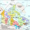
The giant flaw in Canadian maps you never noticed: Mapmakers keep pretending we own the North Pole
It’s a mistake seen in the maps issued by Elections Canada, the National Research Council and the Canadian Armed Forces. It’s even in the official Atlas of Canada and on hundreds of relief maps hung up in schoolrooms across the country. For nearly 100 years, the government of Canada has been printing official maps incorrectly pretending that it owns a U.K.-sized chunk of international waters. “There’s no such thing as having a border hundreds of miles from your territorial lands,” says Heather Exner-Pirot, managing editor of the peer-reviewed Arctic Yearbook.
-
 +17 +2
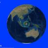
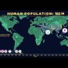
Human Population Through Time
It took 200,000 years for our human population to reach 1 billion—and only 200 years to reach 7 billion. But growth has begun slowing, as women have fewer babies on average. When will our global population peak? And how can we minimize our impact on Earth’s resources, even as we approach 11 billion?
2 comments by rti9
Submit a link
Start a discussion