


-
 +20 +1
FCC unveils new broadband map, offering more data on US internet access
The National Broadband Map's first update in years will provide more relevant information for consumers, businesses, and ISPs.
-
 +17 +1
Revealed: Dutch are least hygienic Europeans
Half of Holland does not wash hands after going to the bathroom. The Bosnians are the cleanest Europeans.
-
 +15 +1
Renewing Inequality
Renewing Inequality maps and explores urban renewal in the United States between 1950 and 1966, focusing upon the more than 300,000 families that the program displaced in more than 600 cities and towns.
-
 +4 +1
+4 +1The Cultural Borders of Songs
We mapped last month’s #1 songs in 3,000 places. See where songs dominate across the globe.
-
 +2 +1
+2 +1Interactive Map reveals most Popular Songs in 3000 International Cities
The Pudding, a website specialising in visual essays, published the interactive map this month, detailing the globe's most-played songs in December 2017.
-
 +25 +1
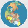
Pangea Supercontinent With Modern Countries Labeled
This is a map of the Pangea supercontinent created by digital artist Massimo Pietrobon with all the modern countries labeled.
-
 +11 +1
Map Of Shakespeare's Play Locations
Shakespeare set his plays in many countries - from Wales to current-day Syria. The interactive map below shows all of the locations that Shakespeare used in his 37 plays.
-
 +1 +1
+1 +1The Battle of Lechfeld 955 AD
-
 +1 +1
+1 +1Creating an Interactive Historical Map [ANNOUCEMENT]
-
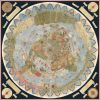
 +25 +1
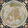
An Ancient Map Shows a World Full of Magical Beasts
More than 60 square feet of cartographic wonder.
-
 +12 +1
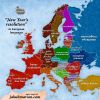
“New Year’s resolution” in European languages
A New Year's resolution is a vow people make to themselves to change an undesired habit or behaviour. The following map shows what New Year's resolutions are called in European languages (different
-
 +15 +1
Alcohol, explained in 35 maps and charts
Learn about one of the world's favorite beverages with these amazing visuals.
-
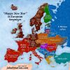 +23 +1
‘Happy New Year’ in European languages
Learn how to wish a "Happy New Year" in German, French, Spanish, Italian and other languages with my neatly coloured map!
-
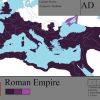 +17 +1
Roman Empire Maps
So I found these maps recently of the Roman Empire. The first has some interesting details about the Roman provinces in general while the second is far more detailed and carefully constructed. If y…
-
 +19 +1
Bizarre, Enormous 16th-Century Map Assembled for First Time
The largest known world map of its time—made of 60 individual sheets—can finally be seen as the mapmaker intended. By Greg Miller.
-
 +13 +1
Google Maps will soon tell you when it’s time to get off your train or bus
Google is about to launch a small but useful update to Google Maps that will give you live guidance and interactive real-time notifications during your..
-
 +8 +1
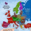
+8 +1Christmas gift-bringers of Europe
Find out who brings Christmas gifts in France, Germany, Spain, and many other countries by looking at this neatly coloured map.
-
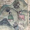 +15 +1
The Library of Congress Acquires and Digitizes a Rare Mesoamerican Codex
The Library of Congress has acquired and digitized the 16th-century Codex Quetzalecatzin, a rare Mesoamerican record of early European contact.
-
 +12 +1
Four Centuries of Mapping the Subterranean World
Boston Public Library's Leventhal Map Center is exhibiting maps of volcanoes, catacombs, mines, subways, sewage systems, and other underground cartography.
-
 +11 +1
Flight Stream
Experiment to map many of the airline flights between world airports. It's <strong>not</strong> showing real time positions (which would be amazing but I don't have that data) but rather, great-circle routes between major airports based on flight data from the Open Flights
Submit a link
Start a discussion