


-
 +6 +1
+6 +1The Surprising History of the Infographic
Early iterations saved soldiers' lives, debunked myths about slavery and helped Americans settle the frontier
-
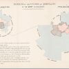
 +34 +6
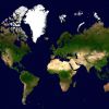
Six maps that will make you rethink the world
The typical world map that hangs on the walls of classrooms is essentially obsolete, says the author of a new book.
-
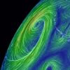 +16 +3
Earth
An animated map of current wind, weather, ocean, and pollution conditions
-
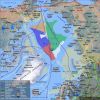
 +19 +4
All the World’s Immigration Visualized in 1 Map
This map shows the estimated net immigration (inflows minus outflows) by origin and destination country between 2010 and 2015. Blue circles = positive net migration (more inflows). Red circles = negative net migration (more outflows). Each yellow dot represents 1,000 people. Hover over a circle to see that country’s total net migration between 2010 and 2015. […]
-
 +14 +5
A Guide to Occult London
If the occult can be defined as a secret knowledge of the hidden and supernatural, then London can claim to be one of the great occult cities... By Robert Greer.
-
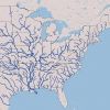 +4 +2
+4 +2Interactive Map of U.S. River Systems
Made with data available from the U.S. Geological Service and the EPA.
-
 +20 +5
The History of Barcelona, in 26 Interactive Maps
Watch the city evolve from 150 A.D. to 2010.
-
 +34 +14
Your Favorite Childhood Video Games Are Now Transit Maps
Metroid, Final Fantasy, and Zelda, all mapped out like your neighborhood metro.
-
 +29 +8
Google Maps And Earth Just Got A Huge Boost: New, More Detailed And Higher Contrast Images
When exploring the planet on the satellite maps, users will be able to examine cities, fields, forests and seas with more clarity, as the new map has lesser clouds compared to the earlier versions. It's also the only second instance of Google revealing a map that is "cloudless." So now, Google Earth tool users will get more detailed and sharper images of the planet thanks to Landsat 8, the new satellite that has better cameras compared to its predecessor Landsat 7.
-
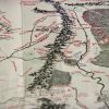 +3 +2
+3 +2J.R.R. Tolkien: Lord of the Rings 'Middle-earth' unveiled
It is a fantasy land through which millions have walked in their own imaginations. Now fans of Lord of the Rings can see Middle-earth as its creator J.R.R. Tolkien did. A previously unseen map, drawn by the author's son Christopher and added to by Tolkien himself, is going on display for one day only.
-
 +19 +3
10 Places Nearly Wiped Off the Map
Here today...
-
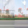 +26 +3
Entire buildings are being deleted from China's 'Street View' and no-one knows why
In September 2014, Jonathan Browning came across a Chinese mystery. Browning, a freelance photographer, was searching for locations on Shanghai's Huangpu River using Baidu Total View - the Chinese version of Google Street View. The Huangpu is Shanghai's main river, and large sections of its banks are lined with soot-stained factories and squat industrial compounds. As Browning looked, he saw that one of these structures - a cooling chimney next to a suspension bridge - had been crudely erased.
-
 +24 +5
The Road Less Traveled? Not Since Waze Came To Los Angeles
The traffic app Waze reroutes drivers from busy, clogged streets to areas with less traffic. But that means some once-quiet neighborhoods are beginning to see traffic jams.
-
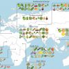 +30 +4
A Map Of Where Your Food Originated May Surprise You
A new study reveals the full extent of globalization in our food supply. More than two-thirds of the crops that underpin national diets originally came from somewhere else — often far away.
-
 +25 +10
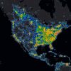
The New World Atlas of Artificial Sky Brightness
Light pollution in urban centers creates a sky glow that can blot out the stars. The brighter the area in this zoomable map, the harder it is to see stars and constellations in the night sky. In the United States, national parks are often a refuge for darkness; national parks are shown in purple in the map below. Check out the globe version of the atlas, too (not compatible with Chrome).
-
 +1 +1
+1 +1Your World Map is Hiding Something
The Mercator projection, the world map we all know, is missing parts of the world because it is cropped at both ends. If you uncrop the bottom, here is the part you don't normally see.
-
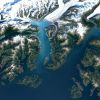
 +18 +3
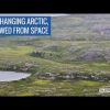
NASA Studies Details of a Greening Arctic
NASA scientists used almost 30 years of data from the NASA/U.S. Geological Survey Landsat satellites to track changes in vegetation in Alaska and Canada. Of the more than 4 million square miles, 30 percent had increases in vegetation (greening) while only 3 percent had decreases (browning).
-
 +30 +4
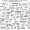
Map Age Guide - XKCD
Guide to figuring out the age of an undated map.
-
 +25 +10
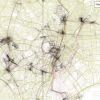
These Lovely Maps Trace the Most Picturesque Routes of Every City in the World
Mapbox's Eric Fischer has been working on the "Geotaggers' World Atlas" for five years, using locations of photos uploaded on Flickr over a decade. In his city maps, which now span the world, he connects the dots between subsequent photos taken by a photographer—representing their path in sketchy lines that criss-cross across the city.
-
 +8 +3
+8 +3The Nuns Who Charted the Stars
At the Vatican Observatory, these women were part of a global attempt to map the night sky.
Submit a link
Start a discussion