


-
 +26 +2
Interactive Map Lets You Track How 19th- and Early-20th-Century American Newspapers Covered Any Topic
This interactive map, put together by the Georgia Tech Research Institute and the University of Georgia's eHistory initiative, uses the Library of Congress' database of historical newspapers, Chronicling America, to track frequency of keywords in newspapers and visualize the results across time and space.
-
 +26 +2
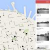
OldSF: Interactive Map of Historical San Francisco Photos
An alternative way of browsing the San Francisco Public Library's incredible San Francisco Historical Photograph Collection.
-
 +26 +2
Mosquitoes on the Move: Zika Virus and the Rise, Fall, and Rise of Aedes Aegypti in the Americas
What can humans do to curtail the spread of Zika? Historian J. R. McNeill (Georgetown University), author of "Mosquito Empires," offers some suggestions based on the long history of the Aedes aegypti mosquito in the Americas.
-
 +27 +2
The Geography of Trumpism
To see what conditions prime a place to support Mr. Trump for the presidency, we compared hundreds of demographic and economic variables from census data, along with results from past elections, with this year’s results in the 23 states that have held primaries and caucuses. We examined what factors predict a high level of Trump support relative to the total number of registered voters.
-
 +22 +2
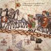
The Silk Road is once more the centre of the world
The Silk Road – from the Eastern Mediterranean to China’s Pacific shore – is once again the centre of the world
-
 +18 +3
Meet the Badass Women Cartographers of Early North America
The first part in a series exploring little-seen contributions to cartography.
-
 +26 +3
The View Across the Ocean Is Not What You Think
As a kid I spent a lot of time on the Maryland shore. Squinting out across the endless blue expanse, I could have sworn I saw the edge of Portugal once or twice.
-
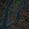
 +29 +3
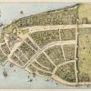
There Used To Be Canals In Downtown Manhattan
Just like in Venice, and that other Venice in Los Angeles, Manhattan once had canals.
-
 +7 +2
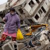
+7 +2The Fall and Rise of Onagawa
A Japanese town devastated by the 2011 tsunami struggles to remake itself.
-
 +47 +2
How Texting Helps Maasai Farmers Avoid Lion Attacks in Rural Tanzania
Cellphones are still relatively new in some parts of Tanzania, but have drastically impacted the way farmers work.
-
 +18 +2
Fascinating maps reveal what our cities sound like
How researchers mapped the spectrum of urban sound.
-
 +23 +2
Point Reyes National Seashore: A Brief History of a Working Landscape
A mere forty windy miles north of San Francisco, Point Reyes National Seashore is a working landscape, containing dairies and ranches that have been in place for generations. However, with mixed use comes disagreement over the proper use of the space and discussions on the purpose of national park system units.
-
 +23 +2
A New Way of Walking
Artist-explorers called psychogeographers are changing the way we experience the city
-
 +9 +2
+9 +2Interview With a Modern-Day Independent Mapmaker
It’s easy to forget that detailed maps can be made by just one person, and that paper maps aren't a thing of the past. Tom Harrison, a California-based cartographer, explains how he collects information and makes his maps, and why he doesn’t hire anyone to help him.
-
 +24 +2
Shells and Shelves
Making money by making companies: another industry that is globalising, consolidating and shifting east. (2012 article about offshore company-creation firms: the many competitors of Panama's Mossack Fonseca)
-
 +17 +2
Where The Hell Is Upstate NY?
We asked 11 New York state historians and academics to try to answer the question.
-
 +12 +2
How Black Pepper Won Europe From a Better Pepper
Long pepper was the first pepper Europe fell in love with, before black pepper took over.
-
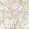 +10 +2
Open Street Map: The simple map that became a global movement
Since its inception in 2004, the growth and maturation of OpenStreetMap is evidenced through numerous metrics: in its data collection methodology, its editorial support infrastructure, its policies and standards, and, of course, in the quality and quantity of its data collection itself.
-
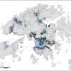 +10 +2
Using Cell Phone Data to Track Segregation in Hong Kong
There’s plenty to learn about where residents travel each day, and with whom they choose to interact. A recent study found a city that is terribly segregated not just by where people live, but across many dimensions of how they move around.
-
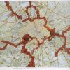
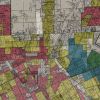 +7 +2
+7 +2Mapping the Lasting Effects of Redlining
Old federal maps and recent Census data combine to show how today's poverty rates align with racist 1930s mortgaging policies.
Submit a link
Start a discussion