


-
 +47 +2
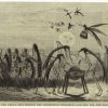
How Texting Helps Maasai Farmers Avoid Lion Attacks in Rural Tanzania
Cellphones are still relatively new in some parts of Tanzania, but have drastically impacted the way farmers work.
-
 +7 +2
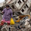
+7 +2The Fall and Rise of Onagawa
A Japanese town devastated by the 2011 tsunami struggles to remake itself.
-
 +29 +3
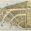
There Used To Be Canals In Downtown Manhattan
Just like in Venice, and that other Venice in Los Angeles, Manhattan once had canals.
-
 +26 +3
The View Across the Ocean Is Not What You Think
As a kid I spent a lot of time on the Maryland shore. Squinting out across the endless blue expanse, I could have sworn I saw the edge of Portugal once or twice.
-
 +18 +3
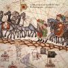
Meet the Badass Women Cartographers of Early North America
The first part in a series exploring little-seen contributions to cartography.
-
 +22 +2
The Silk Road is once more the centre of the world
The Silk Road – from the Eastern Mediterranean to China’s Pacific shore – is once again the centre of the world
-
 +27 +2
The Geography of Trumpism
To see what conditions prime a place to support Mr. Trump for the presidency, we compared hundreds of demographic and economic variables from census data, along with results from past elections, with this year’s results in the 23 states that have held primaries and caucuses. We examined what factors predict a high level of Trump support relative to the total number of registered voters.
-
 +26 +2
Mosquitoes on the Move: Zika Virus and the Rise, Fall, and Rise of Aedes Aegypti in the Americas
What can humans do to curtail the spread of Zika? Historian J. R. McNeill (Georgetown University), author of "Mosquito Empires," offers some suggestions based on the long history of the Aedes aegypti mosquito in the Americas.
-
 +26 +2
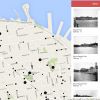
OldSF: Interactive Map of Historical San Francisco Photos
An alternative way of browsing the San Francisco Public Library's incredible San Francisco Historical Photograph Collection.
-
 +26 +2
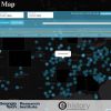
Interactive Map Lets You Track How 19th- and Early-20th-Century American Newspapers Covered Any Topic
This interactive map, put together by the Georgia Tech Research Institute and the University of Georgia's eHistory initiative, uses the Library of Congress' database of historical newspapers, Chronicling America, to track frequency of keywords in newspapers and visualize the results across time and space.
-
 +7 +2
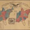
+7 +2When American Voters Had 2 Choices: Whig or Loco Foco
This fascinating electoral map from 1840 documents a chaotic time in American politics.
-
 +26 +2
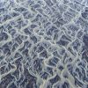
The Stunning Beauty of Braided Rivers
Most rivers flow in one broad channel of water, but some rivers split into lots of small channels that continually split and join each other to give a braided appearance. These are called braided rivers.
-
 +22 +2
MWC 2016: Facebook uses AI to map people's homes
Facebook has announced it will make highly detailed maps of places where it believes people are living available to the public later this year. The social network has been using artificial intelligence software to scan satellite imagery and identify human-built structures. It hopes to use the information to determine where internet-beaming drones would best be deployed. But it suggests others could also make use of the maps.
-
 +7 +2
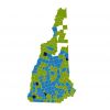
+7 +2What can historic maps reveal about next week's New Hampshire primary?
New Hampshire political history resounds with the names of candidates who used the state's first-in-the-nation presidential primary to vault to the White House. But what did those primary elections look like in the moment, town by town across New Hampshire?
-
 +23 +2
27th January 1888 - National Geographic Society founded
the National Geographic Society is founded in Washington, D.C., for “the increase and diffusion of geographical knowledge.” The 33 men who originally met and formed the National Geographic Society were a diverse group of geographers, explorers, teachers, lawyers, cartographers, military officers and financiers.
-
 +41 +2
How Driverless Cars Will Transform Urban Spaces
You've heard about how robocars are going to upend the economy. But have you thought about what they'll do to urban space?
-
 +40 +3
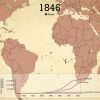
This Haunting Animation Maps the Journeys of 15,790 Slave Ships in Two Minutes
Usually, when we say “American slavery” or the “American slave trade,” we mean the American colonies or, later, the United States. But as we discussed in Episode 2 of Slate’s History of American Slavery Academy, relative to the entire slave trade, North America was a bit player. From the trade’s beginning in the 16th century to its conclusion in the 19th...
-
 +38 +2
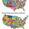
This is actually what America would look like without gerrymandering
It would be easy enough to do. The only thing lacking is the political will.
-
 +27 +2
'Gigantic chasm under Antarctic ice'
A vast, previously unrecognised canyon system could be hidden under the Antarctic ice sheet, say scientists.
-
 +37 +2
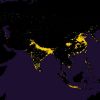
Half the World Lives on 1% of Its Land, Mapped
Feeling a bit cramped right about now?
Submit a link
Start a discussion