


-
 +12 +1
NSW and Victoria just jumped 1.8 metres north
On New Year’s Day, NSW and Victoria jumped north by 1.8 metres – while the rest of the country remained firmly fixed in place.
-
 +18 +1
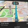
Turn-by-turntables: How drivers got from point A to point B in the early 1900s
Long before GPS, drivers still wanted tech that could simplify the navigation process.
-
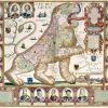
 +16 +1
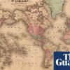
'The perfect combination of art and science': mourning the end of paper maps
Digital maps might be more practical in the 21st century, but the long tradition of cartography is magical
-
 +14 +1
'The perfect combination of art and science': mourning the end of paper maps
Digital maps might be more practical in the 21st century, but the long tradition of cartography is magical
-
 +15 +1
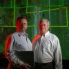
Ancient 'lost city' of the Khmer Empire uncovered in Cambodia
Researchers have identified the elusive ancient "lost city" of Cambodia. Scientists used aerial laser scans and ground-based surveying to map Mahendraparvata, or the Mountain of Indra, King of the Gods.
-
 +25 +1
Google Maps AR walking directions arrive on iOS and Android
Available in beta this week
-
 +26 +1
AI is supercharging the creation of maps around the world
Map With AI, tool created by Facebook researchers and engineers, is helping the OpenStreetMap (OSM) project map missing roads around the world.
-
 +10 +1
First You Make the Maps
How cartography made early modern global trade possible.
-
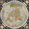
 +29 +1
The world’s oldest medieval map
Created around 1300, it is the largest surviving map from the Middle Ages and offers a glimpse into the mindset of the ancient Christian world.
-
 +17 +1
How mapmakers help indigenous people defend their lands
With help from cartographers, native peoples’ hand-drawn maps of their own territory become a tool against exploitation.
-
 +36 +1
Wizards, Moomins and pirates: the magic and mystery of literary maps
From Moominland to the Marauder’s Map, writers Robert Macfarlane, Frances Hardinge and Harry Potter cartographer Miraphora Mina unfold their favourite maps
-
 +2 +1
+2 +1The World's Newest, Most Gloriously Designed Maps
Cartographers, rejoice. By Anika Burgess.
-
 +13 +1
If an algorithm draws lines on a map, is that the same as land surveying?
Vizaline says its service is not surveying, but Mississippi authorities disagree. By Cyrus Farivar.
-
 +11 +1
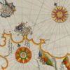
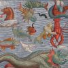
Olaus Magnus’ Sea Serpent
The terrifying Great Norway Serpent, or Sea Orm, is the most famous of the many influential sea monsters depicted and described by 16th-century ecclesiastic, cartographer, and historian Olaus Magnus. Joseph Nigg, author of Sea Monsters, explores the iconic and literary legacy of the controversial serpent from its beginnings in the medieval imagination to modern cryptozoology.
-
 +25 +1
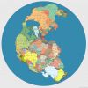
Pangea Supercontinent With Modern Countries Labeled
This is a map of the Pangea supercontinent created by digital artist Massimo Pietrobon with all the modern countries labeled.
-
 +19 +1
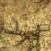
Bizarre, Enormous 16th-Century Map Assembled for First Time
The largest known world map of its time—made of 60 individual sheets—can finally be seen as the mapmaker intended. By Greg Miller.
-
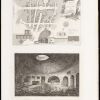 +12 +1
Four Centuries of Mapping the Subterranean World
Boston Public Library's Leventhal Map Center is exhibiting maps of volcanoes, catacombs, mines, subways, sewage systems, and other underground cartography.
-
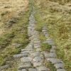 +26 +1
A Very Modern Map of Britain's Ancient Roman Roads
Let's take the VII from Londinium to Letocetum.
-
 +11 +1
Satirical maps of the world
Objective geographical representation isn’t always the intention of maps – they can also provide social, economic or political commentary on a region, as British Library maps curator, Tom Harper discusses.
-
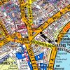 +13 +1
Demystifying the Ancient Tangle of London’s Streets
For 81 years, A-Z maps have helped everyone from cabbies to clueless tourists navigate one of the world’s most confusing cities. By Greg Miller.
Submit a link
Start a discussion