


-
 +23 +1
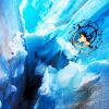
Behind the Picture: Fly Through Clouds and Fog in San Francisco
Discover the story behind this 2016 National Geographic Travel Photographer of the Year entry.
-
 +34 +1
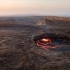
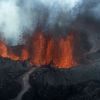
Aerial Photo of Erta Ale Volcano
Photographer:Joel Santos - Shown above is an aerial image of Erta Ale in the Afar Region of northeastern Ethiopia. The caldera of this continuously active, basaltic shield volcano cradles a lake filled with molten lava.
-
 +2 +1
+2 +1Here's How Drone-Maker DJI Will Keep the Phantom 4 from Crashing
This is how the $1,400 drone can basically fly itself.
-
 +15 +1
Aerial Views Of China’s Tulip Fields
China’s tulip farms are a must-see tourist attraction in the warmer months. The farmers have fun with the flowers, creating intricate designs like swirls, zig-zags and even a ying and yang symbol. The beautiful colors are spectacular from the ground, but look even more magnificent from above.
-
 +7 +1
+7 +1The Fragility Of Nature Captured By Daniel Beltrá
Spanish Photographer Daniel Beltrá’s passion for environmental conservation is evident in his stirring images of the natural world. By Paula Lou Riebschläger.
-
 0 +1
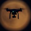
0 +1Is Drone Frame Rate Important?
As if you don’t have enough to think about when it comes to creating stunning drone footage, frame rate is a term which throws most newbie drone operators
-
 +27 +1
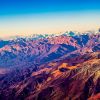
View of the Southern Andes from Aloft
Photographer: Miguel Angel Bosi.The photo above showing the foothills of one of the ranges of the Andes Mountains was taken on a flight between Córdoba, Argentina and Santiago, Chile.
-
 +25 +1
The Rise of the Drone Films
Filmmaker Philip Bloom remembers the first time he tried out a Phantom 2. Shortly after it lifted off the ground, it plummeted into ocean.
-
 +23 +1
40,000 Canisters of Aerial Film from World War II Land Online
Aerial photography dates to the early years of the 20th century, when pioneers like George R. Lawrence launched cameras into the skies with kites.
-
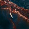
 +21 +1
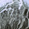
Into the heart of a glacier — with a drone | Robohub
Into the heart of a glacier — with a drone
-
 +19 +1
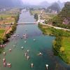
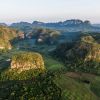
Stunning China (UNESCO World Heritage Sites of Guilin and Yangshuo)
-
 +22 +1
Unseen Cuba: First aerial photographs reveal island's spectacular beauty
Marius Jovaiša is the first artist to get government permission to fly over Cuba and photograph it from above.
-
 +41 +1
Spectacular Drone View of Hong Kong
-
 +44 +1
These aerial photos change familiar places into alien worlds
From the Lake District in England to the desert of Saudi Arabia, see familiar places as never before in these satellite images
-
 +32 +1
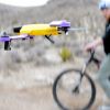
Getting chased through the desert by AirDog, the easiest drone to fly
The Drone 2.0 era is coming, and with it, there's a rising tide of UAVs with a lot more autonomy and a lot fewer of those troublesome joysticks.
-
 +22 +1
DJI - Phantom X Concept
-
 +21 +1
Want a drone for Christmas? So do a million others.
Forget the latest Apple releases: The most in-demand gadgets this holiday season might just be drones.
-
 +46 +1
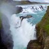
A jaw-dropping aerial tour of Iceland's greatest natural wonders
This breathtaking film condenses an 8-day trip across this land of fire and ice to less than two minutes.
-
 +2 +1
+2 +1360° Aerial Panorama, 3D Virtual Tours Around the World, Photos of the Most Interesting Places on the Earth
AirPano is a not-for-profit project focused on high-resolution virtual tours from a bird’s eye view. Being the largest resource for 360° aerial panoramas in the world – by geographical coverage, number of aerial photographs, and artistic and technical quality of the images, AirPano has already photographed over two hundred most interesting locations on our planet. There are more than two thousand spherical panoramas on our website at the moment.
-
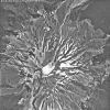
 +37 +1
Aerial view over the Bárðarbunga volcanic eruption
Submit a link
Start a discussion