


-
 +4 +2
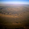
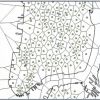
+4 +2The Richat Structure
The Richat Structure of Guelb er Richat in Mauritania is a landmark astronauts see as they pass over the Sahara. Originally thought to be a meteorite impact, it is now known to be a volcanic bulge that never erupted and was leveled by erosion.
-
 +14 +2
30 fake maps that explain the world
These maps may be no good for directions. But they still tell us a lot about the world.
-
 +12 +2
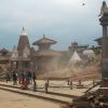
Nepal: Facts About Geology & Culture
Nepal is a narrow, landlocked country directly north of India and below China. Located where two tectonic plates meet, it the area is prone to earthquakes.
-
 +17 +2
Journey To The Center Of The United States
It’s a question that seems so simple as to be stupid, and yet it’s been the focus of debate among American government scientific agencies for over a century: Where, exactly, is the center of the United States of America? In 1901, the U.S. Coast & Geodetic Survey decided, with an oddly cavalier attitude, all things considered, that a place called Meades Ranch, in Kansas, would serve as a survey marker roughly representing the center of the country.
-
 +9 +3
+9 +3Bad Maps Are Everywhere These Days. Here's How to Avoid Being Fooled
Tips from a geographer who's seen it all.
-
 +13 +3
Mapping the U.S. by Property Value Instead of Land Area
Troubling inequities are revealed when you look at the country by total property values.
-
 +3 +2
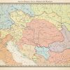
+3 +2Austria-Hungary, early 1900s
While the artist usually does alternate history maps, this is a map done by him that shows our own world's Austria-Hungary and surrounding countries in the early 1900s, before the Balkan Wars.
-
 +3 +2
+3 +2Researchers use Arctic sea floor mapping to piece together earth’s history
Researchers from MacEwan University will use Arctic sea floor mapping research to understand the past, and present a key to the future. “Its about the closest thing we can get to a time machine,” says Mark Furze, of the research that he and Anna Piénkowski, faculty members in the department of Physical Sciences, will be doing over the next three years.
-
 +3 +2
+3 +2Citi Bike Analysis and Automated Workflows with QGIS
Citi Bike, the bike share system in New York City, provides some interesting data that can be analyzed in many different ways using QGIS.
-
 +12 +2
Geocoding: Comparing New & Old Methods
Do new tools available for geocoding addresses improve enough on what we already have?
-
 +17 +2
The Great Boot Debate: Is it time for Louisiana to change its map?
Given the amount of land loss along the coast, some believe Louisiana's iconic boot-shaped map is due for a makeover.
-
 +3 +2
+3 +2The Dustbin of Geography
That picture of you at the Royal Observatory astride the Greenwich Meridian? It's a lie.
-
 +26 +2
An intriguing peek inside one of the only handmade globe studios in the world
A home or office isn't complete without a globe. A beautiful sphere of the world that we can spin on its axis and dream about the next faraway land we'd love to travel to some day.
-
 +22 +2
Where is Point Nemo?
Point Nemo is the location in the ocean that is farthest from land.
-
 +19 +2
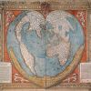
The History of Cartography, the “Most Ambitious Overview of Map Making Ever,” Now Free Online
Worth a quick mention: The University of Chicago Press has made available online -- at no cost -- the first three volumes of The History of Cartography. Or what Edward Rothstein, of The New York Times, called 'the most ambitious overview of map making ever undertaken.'
-
 +16 +2
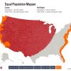
Map of the Week: Equal Population Mapper
The good folks at Slate introduced a creative mapping tool, dubbed the Equal Population Mapper. This interactive graphic allows users to pick a population center (e.g., New York City, Wyoming, the Coasts) and compare its relative density to any area of the United States by selecting a County and watching the map fill in the surrounding area until an equal population is covered.
-
 +26 +2
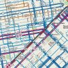
The Big Idea Behind San Francisco's New Rider-Friendly Transit Map
It uses weighted lines to show which buses come more often than others.
-
 +33 +2
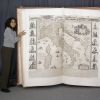
Behold the Largest Atlas in the World: The Six-Foot Tall Klencke Atlas from 1660
Last week, we featured the free digital edition of the The History of Cartography. Or what's been called “the most ambitious overview of map making ever undertaken.” The three-volume series contains illustrations of countless maps, produced over hundreds of years.
-
 +23 +2
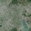
Two Satellite Images That Capture the Explosive Growth of Eastern China
The Pearl River Delta has gone from mostly rural to the world’s largest urban area in three decades.
-
 +18 +2
Photographing the American 'Grid,' One Square Mile Per Frame
The West’s checkerboard plan, devised by Thomas Jefferson, gets the Instagram treatment with striking satellite imagery.
Submit a link
Start a discussion