


-
 +13 +2
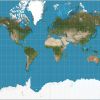
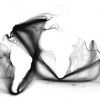
Maps are all lies - How to represent a spherical world on a flat surface
Is Greenland really bigger than Africa and Australia? Take a deep breath. The big map in your high school classroom, the atlas you've used to navigate during a road trip and even google maps are ...
-
 +2 +2
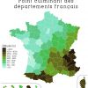
+2 +2France: highest altitude by department map
It's all in the title, i hope :)
-
Interactive+2 +2
GeoGuessr
GeoGuessr is a geography game which takes you on a journey around the world and challenges your ability to recognize your surroundings.
-
 +15 +2
11 Overlay Maps That Will Change The Way You See The World
Nothing is what it seems.
-
 +23 +2
10 Most Bizarre Borders Around the World
There's often an interesting history behind borders.
-
 +20 +2
Painted Ships on Painted Oceans: an Accidental Map of the Doldrums
Take millions of data points, each one a geolocated entry plucked from a digitised collection of 18th- and 19th-century ships’ logs, pin them all on a blank canvas, and you get this extraordinary world map.
-
 +19 +2
China's Chicken Syndrome, and the Man in the Iron Curtain
Stare long enough at these twin images, and you will never see a map of China again without thinking of an agitated chicken flapping its wings as it runs eastward to chase a - what is that?
-
 +34 +2
How the North ended up on top of the map
Why do maps always show the north as up? For those who don’t just take it for granted, the common answer is that Europeans made the maps and they wanted to be on top. But there’s really no good reason for the north to claim top-notch cartographic real estate over any other bearing, as an examination of old maps from different places and periods can confirm.
-
 +21 +2
Cartographers Map Plans as Russia Puts Crimea Border in Play
A vote that could redraw the map of central Europe by joining Crimea to Russia has professional cartographers like Juan Valdes on high alert. In the wake of a referendum scheduled for March 16, Valdes will likely convene a 10-person committee at the National Geographic Society in downtown Washington to determine how the region should be depicted on thousands of print and digital maps.
-
 +20 +2
Why Google Maps gets Africa wrong
At the heart of this is the rise of Google Maps, which has come to dominate cartography today, both in terms of resources and popularity. Billions of searches are made through Google each day, and Google Maps is by far the most widely used smartphone app in the world. Thanks to Google's access to masses of data from satellites, aircrafts and camera-fitted cars, users can see aerial photographs and street maps of virtually the entire planet.
-
 +17 +2
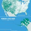
Nobody lives here: The nearly 5 million Census Blocks with zero population
A Block is the smallest area unit used by the U.S. Census Bureau for tabulating statistics. As of the 2010 census, the United States consists of 11,078,300 Census Blocks. Of them, 4,871,270 blocks totaling 4.61 million square kilometers were reported to have no population living inside them. Despite having a population of more than 310 million people, 47 percent of the USA remains unoccupied.
-
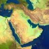 +36 +2
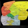
40 Maps That Explain The Middle East
Maps can be a powerful tool for understanding the world, particularly the Middle East, a place in many ways shaped by changing political borders and demographics. Here are 40 maps crucial for understanding the Middle East — its history, its present, and some of the most important stories in the region today.
-
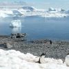 +14 +2
Why do so many nations want a piece of Antarctica?
Seven countries have laid claim to parts of Antarctica and many more have a presence there - why do they all want a piece of this frozen wasteland? I pick a path between rock pools and settle my bottom on a boulder. A spectacular, silent view unfolds across a mountain-fringed bay. Then there is a flash in the shallows by my feet - an arrow of white and black.
-
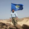 +14 +2
Va. man plants flag, claims African country, calling it ‘Kingdom of North Sudan’
Jeremiah Heaton creates “Kingdom of Northern Sudan” by staking claim to 800-square mile swath of desert.
-
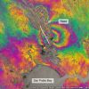 +9 +2
+9 +2New satellite maps out Napa Valley earthquake
Scientists have used a new Earth-observation satellite called Sentinel-1A to map the ground movements caused by the earthquake that shook up California's wine-producing Napa Valley on 24 August 2014.
-
 +4 +2
+4 +2What the world values, in one chart
The Inglehart-Welzel map offers a global look at our values and beliefs.
-
 +24 +2
100 Years of National Geographic Maps
National Geographic maps have charted every mountain, river, lake, road, reef, fjord, island, inlet, glacier, ocean, planet, galaxy, and solar system. The coordinates of the office of The Geographer of the National Geographic Society are 38° 54' 18" N, 77° 2' 12" W. You might say that Juan José Valdés, who currently holds that title, knows exactly where he stands. But the scope of National Geographic's cartographic department, which celebrates its hundredth anniversary this year...
-
 +15 +2
Maps That Shaped the World
Bursting with information and often incredibly beautiful - maps do more than just showing you where you are, or where you might be going.
-
 +21 +2
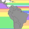
If You Went Straight Across the Ocean, Here's Which Country You'd Hit
Maps can be a tricky thing — just ask Christopher Columbus where he took the wrong turn to "discover" America. Luckily for us, Mental Floss writer Jason English has put together this cool map that highlights which countries you will hit if you start out from the Americas and travel across the ocean in a straight line.
-
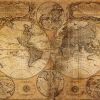 +36 +2
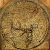
The Mystery of Extraordinarily Accurate Medieval Maps
One of the most remarkable and mysterious technical advances in the history of the world is written on the hide of a 13th-century calf. Inked into the vellum is a chart of the Mediterranean so accurate that ships today could navigate with it. Most earlier maps that included the region were not intended for navigation and were so imprecise that they are virtually unrecognizable to the modern eye.
Submit a link
Start a discussion